Belgium’s commitment to sustainable development in Africa is widely recognized and appreciated.
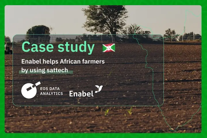
A prime example is the PAIOSA program (Institutional and Operational Support Programme to the Agricultural Sector) in Burundi, which targets the agriculture sector. The Belgian Development Agency, Enabel, funded by the Belgium Government, administers this initiative. It aims to promote sustainable agriculture, improve farmer’s access to financial resources, and encourage the adoption of modern technologies such as satellite crop monitoring.
As part of these efforts, Enabel has incorporated EOSDA Crop Monitoring within its PAIOSA program, employing satellite imagery analytics to empower Burundian farmers with data-driven insights. This case study seeks to highlight the positive impact of precision agritech practices and shed light on the joint efforts of the Belgian and Burundian governments in fostering sustainable food production.
Overview: About Enabel
Enabel is the Belgian federal government’s development agency, responsible for executing its cooperation policies and promoting sustainable international development. Beyond its primate mandate, Enabel undertakes a range of initiatives on behalf of the Belgian federal government. These initiatives include societal development, education and training, public awareness campaigns, the promotion of equitable and sustainable trade, entrepreneurship, leveraging digital technology for development, exploring innovative financing methods, and more. These efforts are all aligned with the pursuit of the United Nations’ Sustainable Development Goals.

Caption: Burundi field worker. Image: Enabel.
Through the PAIOSA program, Enabel provides long-term assistance to farmers and agricultural cooperatives engaged in the production, processing, and marketing of agricultural products. The program particularly focuses on enhancing farming services and infrastructure development, creating an institutional framework that supports entrepreneurial initiatives, and promoting market-driven growth.
H2: Challenges: Poverty And Unsustainable Yields
The escalating impacts of climate change pose significant challenges to agricultural productivity. Enabel supports the transformation of Africa’s agricultural sector to feed its expanding population in a sustainable and healthy way, laying the groundwork for economic growth and reducing inequalities.
Agriculture is a cornerstone of Burundi’s economy, which is among the poorest in Africa. It engages 90% of the working population and provides for 95% of the nation’s food needs. However, factors such as weak productivity, parceled-out farming land, poor water management, and limited capacity for product processing and preservation are structurally limiting agricultural growth.
Agriculture in Burundi also contributes between 40 and 56% of the gross domestic product and generates 86% of export revenues, primarily from coffee, tea, and cotton. The PAIOSA program is designed to enhance the competitiveness of the agricultural sector in Burundi. Funded by the Belgian government, the program has been active since January 2011 and is set to run until June 2024, with a budget of 69.5M €.
“Enabel’s task was to provide continuous and comprehensive support to the development of the agricultural sector in Burundi, including hydro-agricultural works and assistance to local agricultural micro-enterprises/cooperatives and research institutions.”
Joost Noordholland de Jong
Project manager at Enabel/PAIOSA
Solutions: Remote Sensing, Scouting, Comprehensive Analytics
The PAIOSA program initiated satellite monitoring of 4,500 hectares of farmland using EOSDA Crop Monitoring in November 2021. These fields are managed by smallholder farmers located in the irrigated areas of the Imbo plain, the Moso and Kirundo marshlands, and the plots managed by the Integrated Farmer Field Schools.
EOSDA Crop Monitoring equips Enabel’s agricultural professionals with the ability to analyze five key vegetation indices, four of which assess plant health:
- Normalized Difference Vegetation Index (NDVI)
- Red-Edge Chlorophyll Index (RECI)
- Normalized Difference Moisture Index (NDMI)
- Modified Soil-Adjusted Vegetation Index (MSAVI)
- Normalized Difference RedEdge (NDRE)
Data is captured and evaluated twice per week at a resolution of 10 x 10 meters per pixel. Continuous monitoring of indices over time is crucial for assessing the homogeneity and developmental stages of the crops.

Caption: Time-lapse images of the Musasa swamp (98 ha, divided into five autonomous units) planted with rice on August 17, 2022, and harvested on January 1, 2023. The greener and more consistent the color, the higher and more uniform the NDVI index, indicating plant vigor. Notably, in the middle of the campaign (October 2022) and near the end of the harvest period, the rice matures and begins to dry in the fields, which is reflected in the decreasing NDVI index (turning red). Image: Enabel.
For the Farmer Field Schools, satellite imagery was supplemented with drone photography. The NDVI of each pixel is used as a baseline parameter for identifying field anomalies. After initial satellite and drone data analysis, PAIOSA assigned Scouting tasks to colleagues in the field to verify the situation and identify the origins of the heterogeneity/anomalies observed (such as disease, sowing delays, nutrient deficiencies, etc.). The combination of remote analytics and in-person reports provides sufficient data to offer targeted recommendations for the affected areas, addressing issues related to soil fertility, planting schedules, and diseases, with the ultimate goal of enhancing harvest yields and family incomes.

Caption: Temporal images of CEPI Nyagisozi 04 (Bugesera) sown in mid-October and partially harvested on January, 10, 2023, highlighting deprived areas. The consistent green spots over time indicate trees. Image: Enabel.

Caption: Composite images of CEPI Nyagisozi 04 (Bugesera) created from drone footage. The 3D map (left) verifies the adequacy of the level curves relative to the terrain. The composite map (right) shows the current vegetation and crops. Image: Enabel.
Rainfall forecasts for up to two weeks ahead, available via EOSDA Crop Monitoring, are also used on a regular basis. They serve as an advisory tool for determining optimal sowing times, fertilizer application, and other agricultural activities, and can be considered in conjunction with vegetation indices like NDVI. The accuracy of these forecasts is consistently verified by comparing them with data from IGEEBU data. Weather predictions have proven to be crucial for local farmers in Burundi, especially during certain times of the year.
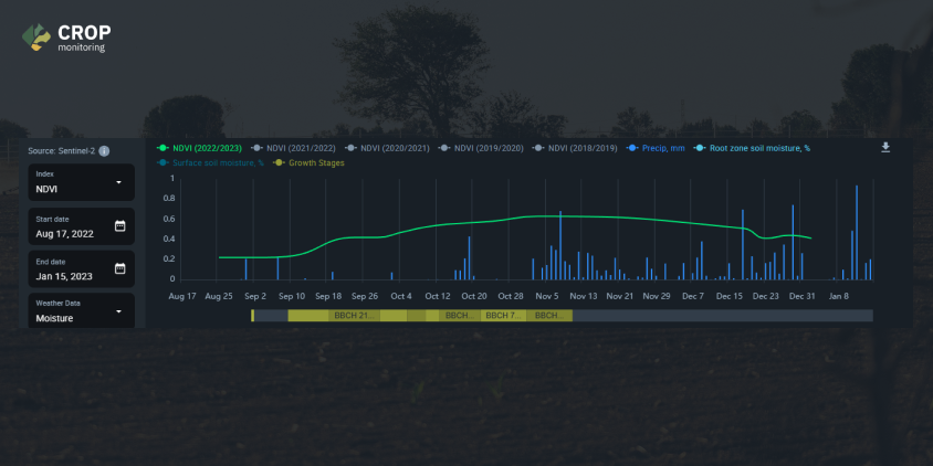 |
| Caption: Overlay of rainfall forecasts, NDVI, and growth stages, indicating a delay in vegetative growth (green “NDVI” curve with a horizontal trend) due to a drought period (September 18 – October 4). Image: EOS Data Analytics. |
Results: Yield Optimization, Soil Erosion Monitoring
In summary, the integration of satellite images with field visits allows for a more precise analysis of crop health. Real-time verification of crop types, the implementation of contour lines, and the identification of critical erosion areas are made possible through drone imagery. This facilitates a deeper understanding of the correlation between the data from EOSDA Crop Monitoring and the actual situation on the ground.
“For the next phase of the Program, 2024-2028, Enabel will consider further exploring the potential of these tools and their complementarity to have better visibility in advanced remote monitoring of their agricultural interventions. This will include more extensive team training and the consistent laying and analyses of targeted yield squares,” says Joost Noordholland de Jong, Program manager at Enabel/Paiosal
The primary goal of the PAIOSA program is to foster sustainable economic growth in Burundi by addressing the challenges related to agricultural production. Through the use of remote sensing analytics from EOSDA Crop Monitoring, PAIOSA is making strides in improving field productivity, increasing the value added from agricultural production, and expanding income-generating opportunities, all while diligently protecting and sustaining the region’s precious natural and environmental resources. This holistic approach ensures that the program not only spurs economic growth but also maintains a strong and continued commitment to the environment and the well-being of the people of Burundi.
Originally published on eos.com.
References:
- Pathways To Sustainable Development. First Belgian National Voluntary Review On The Implementation of 2030 Agenda. Michel, C. (2017, July).
- Programme d’Appui Institutionnel et Opérationnel au Secteur Agricole (PAIOSA) : amélioration de la compétitivité du secteur agricole. (2022, August 30). Enabel
- Burundi country profile. (2023, July 31). BBC.